Atlas of Palestine 1917–1966
The Palestine Land Society (London) has announced that the Atlas of Palestine 1917–1966 has been published in April 2012, in Arabic. This Atlas is a compendium of twenty years of hard work by Dr. Salman Abu Sitta, collecting information from several countries, analyzing and reviewing data in Geographic Information Systems (GIS) software. The current Atlas covers the entire area of Palestine from Rā’s al-Naqūra to Umm Rashrash, and from Rafah to the Jordan River. It covers the period since the Balfour Declaration and British Mandate over Palestine and the Nakba in full detail and recounts the looting, destruction and confiscation of Palestine by Israel.
The Atlas includes:
1,600 towns and villages
65 tables
30,000 place names
95 illustrative maps
30 photos and figures
The Atlas of Palestine contains 150 pages of analysis of the following topics:
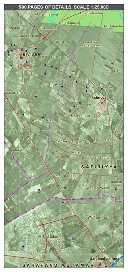
The partition of Palestine, how the borders of Palestine emerged, land ownership in Palestine, the people of Palestine, the War of 1948 and the Nakba (catastrophe), the armistice lines, war crimes, the destruction of Palestine, the seizure of Palestinian property and confiscation, water, agriculture, dispersal of the refugees, the transformation of the character of the country from Palestinian into Israeli, and the plan for refugee return. The Atlas also contains 500 pages of maps of the whole of Palestine.
The intended public for this Atlas is Palestinian youth everywhere, especially in the camps, in order to help young people identify with their homeland with scientific and legal precision. The ideal setting for using the Atlas is through education at home, in discussion with parents and grandparents. The author intends also to promote the Atlas and its contents through visits the camps in and surrounding Palestine.
Here you can access an introduction to the Atlas (in Arabic). You can find further information on the site of the Palestine Land Society.
|