Loss and Damage in Iraq: The Marshes as Example
Iraq ranks fifth among the most climate-affected countries in the world. Iraqi society has become considered the most fragile due to its influence and being affected by negative environmental components arising from serious environmental deterioration, resulting from two devastating wars, a decade of siege, and the continuation of conflicts after the year 2003, which led to the complete destruction of 7% of the water infrastructure of dams, irrigation canals and pumping stations. In addition to the mismanagement of the water file, the lack of organization and adherence to instructions and regulations in various works and development projects, as well as, transgressing the river and green cover sanctuaries, all lead to high levels of pollution. A serious change in the environment has taken place, with recurring dry seasons and water shortages becoming a feature of climate change in Iraq.
Today, Iraq faces many regional and national water management and control challenges due to increasing climate variability as well as water scarcity, resulting in part from the decline of water courses from neighboring countries. Drought has affected northern Iraq since early 2021, while southern governorates have seen declines in water supply and quality for several years. Crop and livestock production has since declined, impacting vulnerable communities affected by conflict and displacement over the same period. At least seven million people in Iraq have been affected by drought recently. The increasing severity of drought in Iraq has led to the displacement of more than 62,000 people from all over Iraq over the past four years.
The drying of the marshes
In Iraq is no greater example of the combined effects of mismanagement amid climate change than the marsh area, which is located in the vast floodplains between the Euphrates and Tigris rivers in the lower part of the Iraq basin. The marshes lie mostly within southern Iraq and a portion of southwestern Iran. In Iraq, they occupy a triangular zone across the three governorates of Dhi Qar, al-Basra and Maysan, formed by the three outlying cities: Nasiriyah, Basra and al-Amarah.
Many factors have contributed to the destruction of the marshes, the most important of which are the construction of dams upstream by Turkey and Iran, oil exploration that contributed to the drying up of 950 km2, and military operations, including most directly due to the deliberate drainage of the wetlands by Saddam Hussein as an act of retaliation against the 1991 uprisings against his regime.
That vengeful operation led to the fact that the Iraqi marshes, whose area ranges between 10,500 km2 and 20,000 km2, no longer can perform their biological and ecological function, but rather are barren lands scarred by years of drought. The area of Iraq`s southern marshes have shrunk from 20,000 km2 in the early 1990s to 4,000 km2 today.
Last July, the United Nations FAO launched an urgent appeal to warn of the dire consequences of climate change and water scarcity on the marshes in southern Iraq. The region has witnessed the most severe heat wave in several years, accompanied by a sudden water shortage in the Euphrates River, which forced... Many of them have to leave their villages and migrate to the governorates of Salah al-Din, Najaf, Karbala, and Babil in central Iraq, and other areas, in search of usable water, food and fodder for their livestock, and job opportunities.
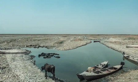
The waterways in the marsh areas in southern Iraq were covered with lush green grasses and the weather was very pleasant at the end of the winter season, as buffalo breeders and hunters were actively working in the marsh areas, which contributed 60% of the fish wealth in Iraq. But after the water shortage, it became completely dry without water, and there were no buffalo breeders or hunters. The cane crop also dried up and the population abandoned the area.
As soon as you take one step onto the land, you feel extremely hot due to the change in the environment of the region, as the marshes used to help reduce temperatures. Now, after the drying of the marshes, midday temperatures reach 50 degrees Celsius. The marsh area, due to climate changes, has dried up by 85% of its area and by 80 cm below its natural level, which has led to the displacement of 2,345 families from Dhi Qar Governorate. Although the Iraqi government has put in place a set of measures to preserve and sustain the marshes, it has not included within its policies an assessment of the damages and non-economic losses incurred by local communities from loss of livelihoods, forced migration as a result of the drought wave and the destruction of the marsh ecosystem.
In addition to the practices of the former Iraqi regime, one of the main reasons for drying up the marshes’ water is Turkey’s construction of 30 dams to store water within its territory, without consulting neighboring countries that benefit from the water in accordance with international law. Environmental experts also expected the ecosystem to be frozen. The livelihood of fishermen was destroyed, and the number of unemployed people doubled in the northern Gulf, near the Kuwaiti border, in addition to the migration of 100,000 residents of the marshes to Iran, according to official statistics, and the displacement of thousands more within Iraq after the population of the region reached half a million people, and nothing remained. Of these marshes, only 2,000 km2 in an area near the Hawizah region represents a tenth of its original size.
The FAO has warned that the situation has become worrying, as the water level in the Euphrates River has reached only 56 cm, and in the marshes from 0 to 30 cm, with a dangerous drought rate reaching 90%, and high salinity levels, which exceeded 6,000 ppm has raised concerns among farmers, especially buffalo breeders and fishermen. In addition, approximately 70% of the marshes are devoid of water, according to the Iraqi Marshes and Wetlands Revitalization Center of the Ministry of Water Resources.
The marshes of Iraq and the culture of the Marsh Arabs (the Ma`dan) occupied a distinguished place on the UNESCO World Heritage List. The Ma`dan continued to hunt animals and fish in this marsh area for 5,000 years, and they built houses of woven reeds on floating islands where the Tigris and Euphrates rivers meet before emptying into the Gulf. What prompted UNESCO to place it on the World Heritage List, and the efforts it entails fall on the responsibility of the Iraqi government, including protecting the marsh areas and archaeological cities, while developing them and ensuring their sustainability, to perpetuate environmental diversity, and providing expertise and funding to preserve the natural beauty of the marshes, and preserve the diversity of life, natural and animal resources. The decision also included recognition of the need to work to encourage the return of the marshes’ inhabitants to them.
Loss and Damage
Several assessments of the consequences of drought amid the multiple crisis of environmental destruction due to dams in Iran and Türkiye and serial occupations and conflicts. Some have led to emergency plans of action and a proposed 5-year National Plan for Reconstruction and Development of Iraq and a Reform, Recovery and Reconstruction Fund. The International Organization for Migration also surveyed more than 2,800 households across farming communities in conflict-affected governorates of Dhi Qar and Basra, where the marshes are found, as well as Anbar, Duhok, Kirkuk, Ninewa and Salah al-Din governorates.
With farmers experiencing detrimental crop losses, incomes have dropped for farming households. In Basra, more than half of households rely on agriculture as their main source of income, and revenues have plummeted. The average monthly income among surveyed households is IQD 288,000 (US$219) in Basra, which is significantly lower than the IQD 440,000 (US$335) required to meet the monthly Survival Minimum Expenditure. The majority of farmers lease their land from the government, which effectively means they are paying rent, while their crops continue to fail and they have no income.
The drought has decreased employment opportunities for daily workers; 80% of farmers did not have any temporary wage workers in 2020–21. An estimated further 20% decrease in Iraq’s water supply could decrease demand for agricultural labor to 11.8% and reduce Iraq’s GDP by US$6.6 billion. Notably more than a quarter of IDPs rely on daily work as their main source of income. The inability to access income will only further exacerbate existing vulnerabilities for displaced communities and contribute to more serious negative coping mechanisms or additional waves of displacement.
Additional losses include the lack of food, costs of displacement, loss of income and increasing food prices. This is particularly urgent considering dire drought forecasting and the recent Ministry of Agriculture decision to reduce the country’s annual areas for cultivation by 50% for the 2021–22 cropping season due to water scarcity.
A 5-year-old World Bank Group needs assessment covered loss and damage due to conflict in seven governorates: Anbar, Diyala, Ninawa, Salah al-Din, Babel, Baghdad and Kirkuk. The data and findings are significant, but do not cover the afflicted marsh region and provide only macroeconomic data, which broad scope assists in national-sphere planning, but averts the focus from communities and their specific costs, losses, damages and consequent needs.
However, that assessment is instructive in projecting remedial efforts in an integrated manner at renewal of the social contract, promoting economic and business recovery and rehabilitation of services.
With respect to UNESCO’s designation of the marshes to be a World Heritage Site, the nontangible losses from destruction of the marshes are invaluable, but do not figure in any loss and damage assessment so far. Furthermore, the loss of civil peace needs to be counted also. Notably, the situation began to change after 2004 when reduced levels of water flowing from the Tigris and Euphrates enabled seawater from the Gulf to intrude deeper and deeper into the Shatt al-Arab, eventually reaching Basra itself for the first time in 2018, which led to mass unrest.
A wider scope and more granular detail of community impacts and their wider implications are needed to determine actual and potential loss and damage. This corner of Iraq provides a specific case in point.
Photo: In the central Chibayish marshes, only small puddles of polluted water remain.
Source: Ghaith Abdul-Ahad.
|